|
Company |
|||||||||
|
|||||||||
Press Release | ||||||||
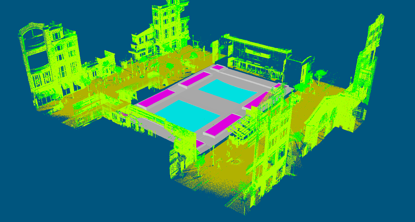
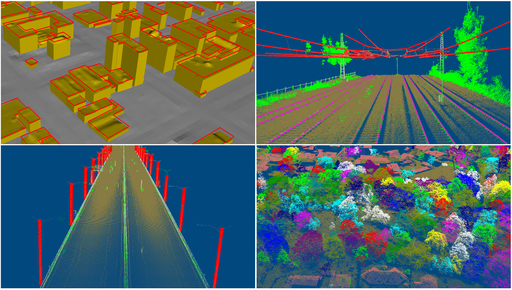
» 2/2/2026: VRMesh AI Introduces High-Performance 3D Annotation Platform for Physical AI | ||||||||
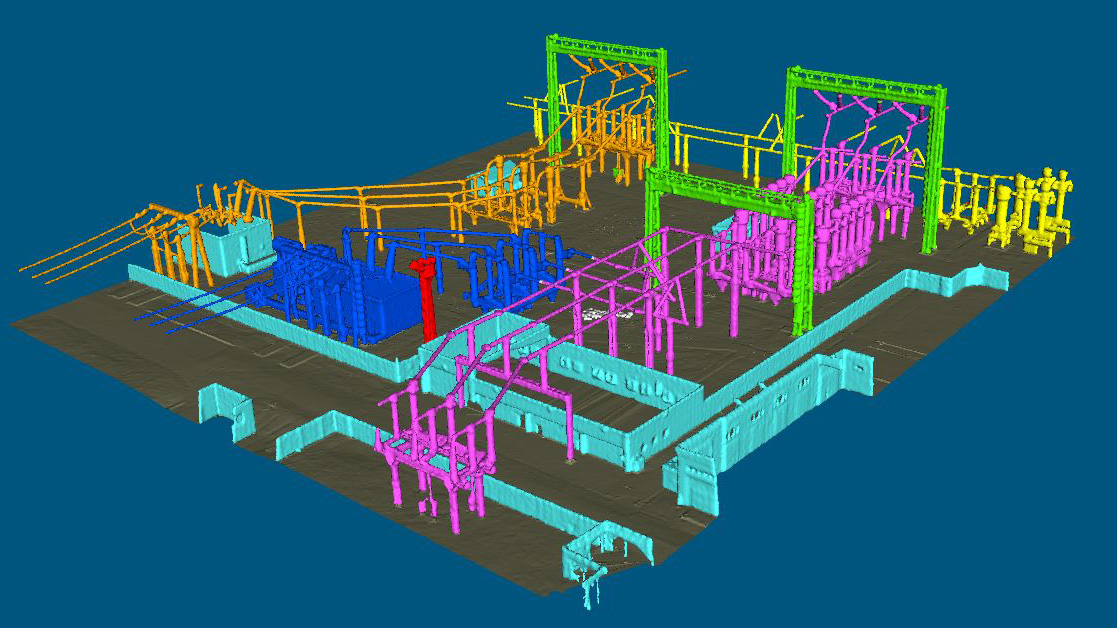
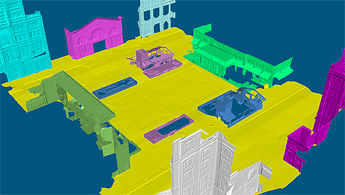
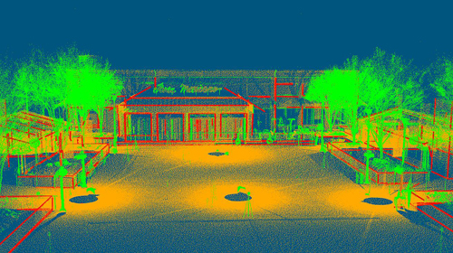
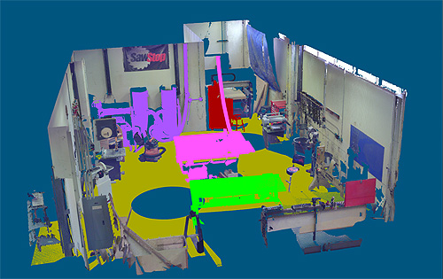
VirtualGrid unveils VRMesh AI, a high-performance 3D annotation platform built to support Physical AI, humanoid robotics, and digital twin development. The platform enables teams to efficiently convert raw data into high-quality, AI-ready training datasets. VRMesh AI provides a comprehensive 3D data workflow, including point cloud cleanup, high-accuracy meshing, advanced mesh segmentation with edge and corner detection, and multi-layer mesh labeling. The platform is optimized for large, complex datasets and delivers high annotation accuracy for real-world robotics applications. By accelerating data preparation and improving training data quality, VRMesh AI helps organizations build more capable and reliable Physical AI systems.
| ||||||||
» 1/8/2024: VRMesh V12.0 Adds Polygon Modeling | ||||||||
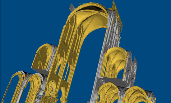
VirtualGrid is delighted to unveil VRMesh v12.0, the most recent iteration of its user-friendly and versatile point cloud processing software. Renowned for its distinctive technologies encompassing point cloud classification, feature extraction, and point cloud meshing, VRMesh continues to offer advanced capabilities for efficient data processing. In this latest release, a significant addition comes in the form of polygon modeling. Now, you can create, edit, and optimize polygons directly on point clouds, allowing you to export a precise low-poly mesh for subsequent Industries. The comprehensive workflow provided by VRMesh enhances efficiency and boosts productivity in the fields of architecture, engineering, and construction. Site design typically involves the use of multiple software tools, each serving a specific function. For instance, one tool may be employed for point cloud classification and feature line extraction, while another handles polygon modeling. This segmented approach can be time-consuming and costly. VRMesh offers a streamlined and cost-effective solution by automating point cloud classification, directly fitting a polygonal surface to point clouds, and allowing for easy editing of a polygonal surface on point clouds. In the end, all components seamlessly merge into a single, highly accurate low-poly model. The new version now supports the GLTF format, enabling you to export projects with multiple textured objects into a single file. This functionality is particularly useful for digital twin Industries, including platforms like Nvidia Omniverse, Unreal Engine, or Unity. For a live demonstration, visit Booth 921 at Geo Week, taking place from February 1 to 3, 2024, at the Colorado Convention Center in Denver. We look forward to showcasing our versatile workflows across various Industries.
| ||||||||
» 1/4/2023: VRMesh V11.8 Adds New Features for Digital Twin Creation | ||||||||
VirtualGrid is pleased to announce the availability of VRMesh v11.8, the latest version of its powerful point cloud and mesh processing software. VRMesh is the best solution for creating an accurate digital twin to represent industrial facilities and the environment in urban planning. It provides you with automatic point cloud classification, intelligent feature extraction, and accurate point cloud meshing.
This new release adds more functions, for example, mapping an image onto a surface, embossing a surface according to the luminance value of a texture, supporting LandXMI file format, etc. VRMesh provides a comprehensive toolset and flexible workflows for a wide range of industries such as construction, land surveying, mining, energy, utilities, architecture, manufacturing, VR gaming, etc. to make engineers' jobs easier and to maximize productivity at work. For a live demonstration, please stop by Booth 426 at Geo Week from Feb. 13 - 15, 2023 at Colorado Convention Center in Denver. We are pleased to show you our innovative technologies.
| ||||||||
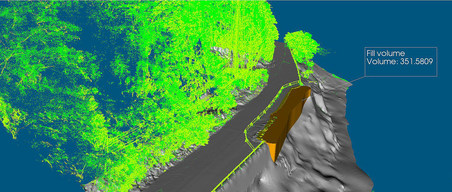
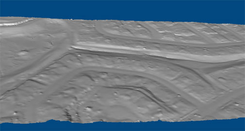
» 6/8/2022: VRMesh V11.7 Focuses on Cut and Fill Volume Calculation | ||||||||
VirtualGrid is pleased to announce the availability of VRMesh v11.7, the latest version of its powerful point cloud and mesh processing software. This release focuses on the cut and fill volume calculation. The new version of VRMesh provides you with a push/pull tool to create cut and fill parts for accurate volume calculation, instead of traditional methods using cut or fill depth multiply the value by area of the grid cell to get an approximate volume. The cutting-edge technologies in VRMesh make easy-to-use tools for your mining and construction projects.
VRMesh covers point cloud classification, feature extraction, and point cloud meshing. It provides a streamlined workflow and a comprehensive toolset for making engineers' jobs easier and maximizing productivity at work. VRMesh customers span across various industries such as land surveying, construction, mining, energy, utilities, architecture, entertainment, medical/dental, etc. | ||||||||
» 1/20/2022: VRMesh V11.6 Improves Workflow for Point Cloud Processing | ||||||||
VirtualGrid is pleased to announce the availability of VRMesh v11.6, the latest version of its powerful point cloud and mesh processing software. VRMesh is best known for its unique technologies including automatic point cloud classification, feature extraction, and accurate point cloud meshing. This new release not only adds more functions to point cloud processing, but also provides users with more flexibility to customize workflows for maximizing productivity at work. The key improvements include:
VRMesh provides flexible workflows for processing all kinds of point clouds collected from airborne/mobile/terrestrial LiDAR. You can auto-classify and clean up point clouds, extract different feature lines, generate accurate surface meshes, and make an inspection and measurement. VRMesh customers span across various industries such as land surveying, construction, mining, architecture, manufacturing, VR gaming, etc. For a live demonstration, please stop by Booth 822 at ILMF/SPAR3D 2022 from Feb. 6 - 8, 2022 at Colorado Convention Center in Denver. We are pleased to show you our innovative technologies. | ||||||||
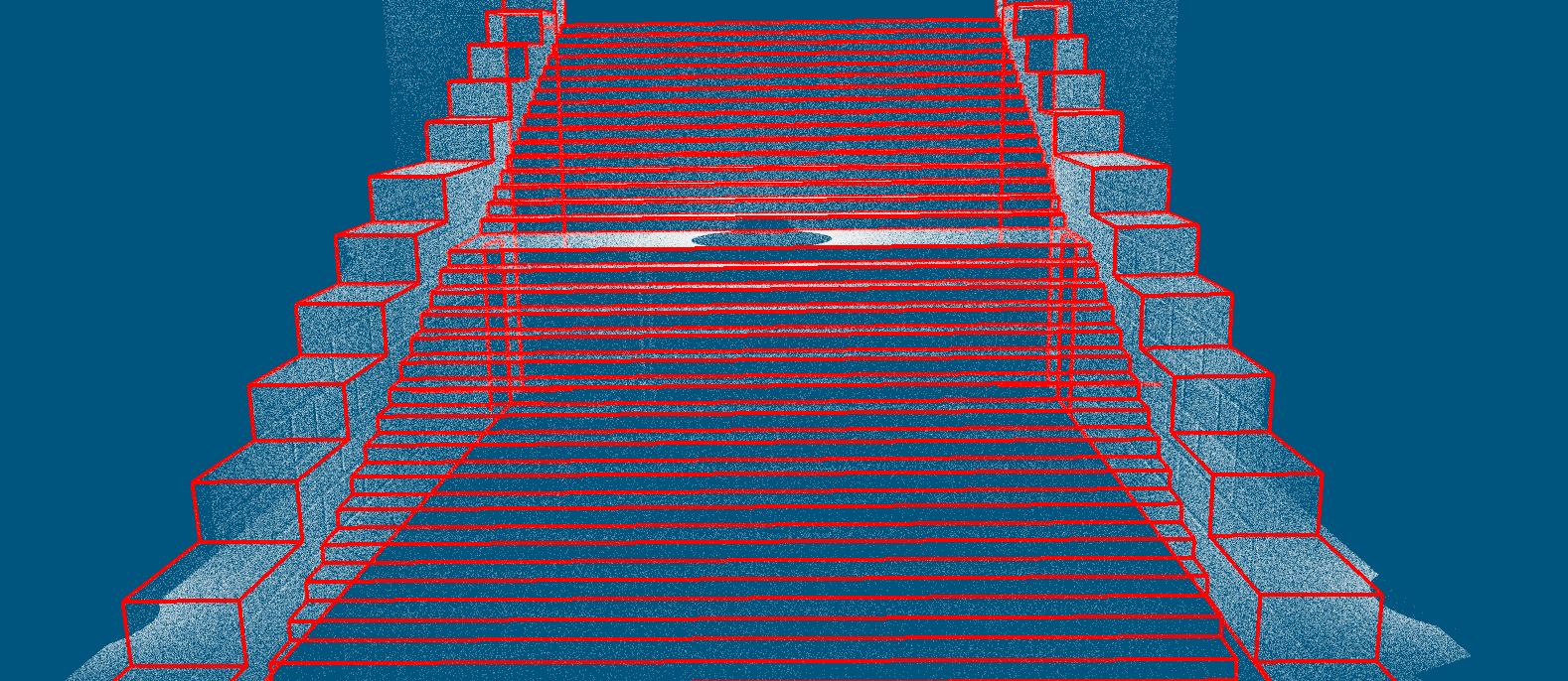
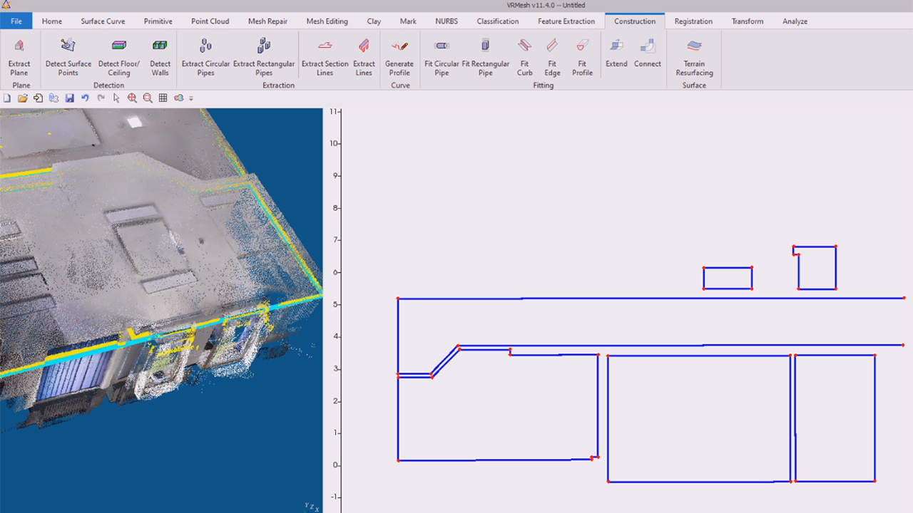
» 3/31/2021: VRMesh V11.4 Adds Classification on Meshes and 2D Plan Extraction from Point Clouds | ||||||||
VirtualGrid is pleased to announce the availability of VRMesh v11.4, the latest version of its powerful point cloud and mesh processing software. This release adds more functions into the streamlined workflow provided by VRMesh for the architecture, engineering and construction (AEC) industry. VRMesh is the best known software tool for point cloud classification. In this release, it adds a new function to let you perform classification on meshes directly. You can detect different planes and parts, which makes it easy to manage and visualize assets for digital twin Industries.
Another new function added, extracting section lines, focuses on building information modeling (BIM). It provides you a set of tools to trace cross-section lines automatically and edit lines manually for creating a detailed 2D plan on point clouds.
Meanwhile, some commands are enhanced. Uniform remesh is added in the refinement command. ASPRS reserved class field can be easily renamed according to your Industries. The arrow navigation is improved. With these cutting-edge technologies, VRMesh provides flexible workflows for a wide range of industries, such as construction, architecture, land surveying, mining, energy, manufacturing, etc. | ||||||||
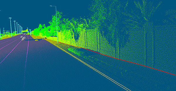
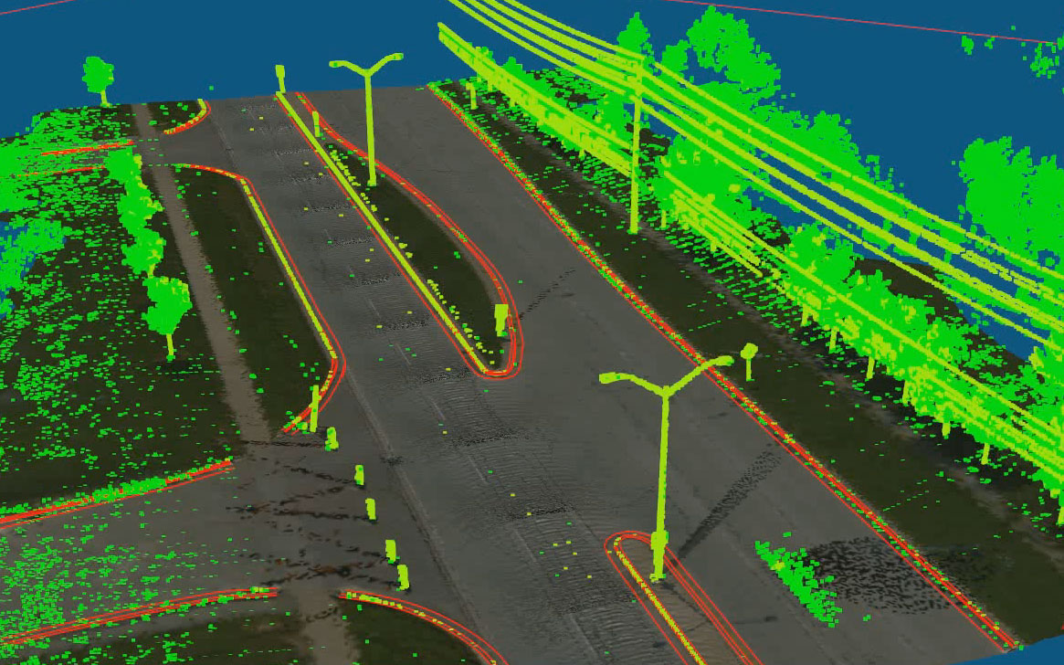
» 10/05/2020: VRMesh V11.3 Focuses on Breakline Extraction | ||||||||
VirtualGrid is pleased to announce the availability of VRMesh v11.3, the latest version of its powerful point cloud and mesh processing software. This new release focuses on automatic breakline extraction from point clouds. VRMesh provides an industry-leading solution for point cloud classification and feature extraction. It can extract building footprints, powerlines, poles, tree crowns, and curbs from point clouds automatically. One of the new features included in this release, inspired by customers' feedbacks, allows you to trace breaklines directly among different point cloud classes with one click only. As an improvement, curb detection is also redesigned to extract curb breaklines instead of curb centerlines from point clouds.
VRMesh has been the best tool for converting point clouds to accurate meshes. With accurate meshes as a foundation, automatic breakline extraction from meshes, avaliable since the previous version, has also been VRMesh's leading feature. In this new release, you can extract breaklines either from surfaces as before or directly from point clouds. These functionalities of extracting breaklines provided by VRMesh will make engineers' jobs easier and maximize productivity at work. This release also includes a new feature which enables you to calculate the property value (Intensity/Slope/Elevation/Curvature) for individual points and reclassify these points. The functions of extracting powerlines, poles and trees are enhanced from previous versions as well. VRMesh provides a comprehensive streamlined workflow from classification to feature extraction. With these cutting-edge technologies, VRMesh serves a wide range of industries including, but not limited to, construction, architecture, land surveying, mining, energy, and manufacturing. | ||||||||
» 03/02/2020: VRMesh V11.2 Adds Two-Sided Meshing for Visualizing Large-Volume Scans | ||||||||
VirtualGrid announced today the release of VRMesh v11.2, the latest version of its powerful point cloud and mesh processing software. This release presents a new method of point cloud meshing that enables users to convert point clouds to a two-sided mesh for visualizing intricate environments such as construction sites. As a technology pioneer in the field of point cloud meshing, VRMesh has been famous for creating an accurate mesh to represent original objects with high details. Today, VRMesh is pleased to present a new functionality that creates a two-sided mesh surrounding point clouds, which works well on thin shapes, such as tree leaves, and poor scans. This functionality is suitable for visualizing large-volume scans. Overall, the point cloud to mesh function in VRMesh has become more powerful as it not only can produce an accurate mesh in great detail but also can create a two-sided mesh for visualization and measurement. Furthermore, VRMesh v11.2 supports 3DConnexion SpaceMouse.
This release also includes multiple new marking tools that allow users to label the regions they want for creating visual deliverables and to extract breaklines with slope analysis. Today, the cutting-edge technology of VRMesh is especially well known in the geospatial and reverse engineering industries. It provides a streamlined workflow and the most comprehensive toolset in the market to make engineers' jobs easier and to maximize productivity at work. VRMesh customers span across various industries such as land surveying, construction, mining, architecture, manufacturing, entertainment, medical/dental, etc. For a live demonstration, please stop by Booth 414 at International LiDAR Mapping Forum (ILMF) 2020 in Washington, DC. from March 23 - 25. We are pleased to show you our innovative technologies. | ||||||||
» 09/17/2019: VRMesh V11.0 Launches New Engine of Point Cloud Meshing | ||||||||
Sep. 17th, 2019 - VirtualGrid is pleased to announce the availability of VRMesh v11.0, the latest version of its powerful point cloud and mesh processing software. VRMesh is best known for its cutting-edge technologies in point cloud classification, feature extraction and point cloud meshing. It provides a streamlined workflow for the AEC industry. The key highlights in this new release include:
In version 11, VRMesh introduces a new engine of point cloud meshing that makes the process of converting point cloud to mesh ten times faster than previous versions. For example, converting 10 million points to meshes takes a few minutes using the new engine. Comparably, it takes a few hours to process such a large dataset in previous versions on the same computer. For this reason, the new version of VRMesh lets the point cloud meshing function become more powerful than before. The program works with any type of point clouds generated from LiDAR or photogrammetry and any size of point clouds.
Another exciting thing in this new release is that VRMesh provides more classification functions for architecture and construction. With these functions, the program can detect lines in point clouds automatically, which allows you to extract lines directly from 3D scan data of buildings, bridges, tunnels, etc. Additionally, the program can detect floor/ceiling/walls and extract all pipes from point clouds with just one click.
Meanwhile, IFC format is supported in version 11 that allows you to load a CAD model into VRMesh for construction verification with point cloud data. STEP and IGES are also supported. With these cutting-edge technologies, VRMesh provides comprehensive point cloud and mesh processing tools and flexible workflows for a wide range of industries, such as construction, architecture, land surveying, mining, energy, manufacturing, etc. | ||||||||
» 04/03/2019: VRMesh V10.3 Provides Water Catchment Analysis | ||||||||
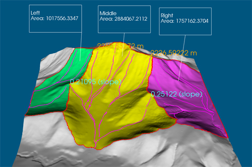
Apr. 3rd, 2019 - VirtualGrid is pleased to announce the availability of VRMesh v10.3, the latest version of its powerful point cloud and mesh processing software. This release has added a new feature for water catchment analysis. VRMesh provides a streamlined workflow covering everything from automatic point cloud classification to accurate point cloud meshing. Analyzing water catchment becomes easy based on a high-quality 3D terrain surface. The program can quickly calculate the direction water will flow, find catchment areas, trace water flow paths, extract catchment boundaries, as well as do some measurements, such as the length/average slope of a flow path and the area of a catchment. VRMesh provides detailed water flow information for realistic 3D hydrological modeling.
With these cutting-edge technologies, VRMesh becomes the most comprehensive point cloud and mesh processing software tool in current market. Our customers come from a wide range of industries, including land surveying, construction, transportation, energy, environment, mining, etc. | ||||||||
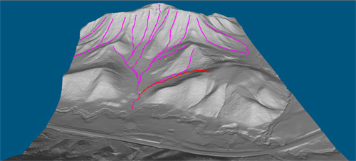
» 01/23/2019: VRMesh V10.2 Adds Water Flow Tracing | ||||||||
Jan. 23rd, 2019 - VirtualGrid is pleased to announce the availability of VRMesh v10.2, the latest version of its powerful point cloud and mesh processing software. This release has added a new feature that can automatically trace water flow paths. Unlike traditional point cloud classification workflows that have to extract ground points first before classifying vegetation and buildings, the first fundamental step in VRMesh classification is to detect vegetation directly. The major benefit of our workflow is to make it working well under extreme variations in terrain. Furthermore, VRMesh meshing functions can create high accurate surface in details from ground points. The two key technologies: point cloud classification and meshing, promise VRMesh can trace water flow paths correctly.
Meanwhile, some commands are enhanced. The distance widget supports slope calculation between two points. The Points by Slope command adds a value label to show the degree of a slope and allows you to export a screenshot to a PDF report. The two functions can be used to check out the floor flatness. Additionally, the Pick Road Markings command is enhanced to trace polylines based on colored points from intensity as well as from RGB values. For a live demonstration, please stop by Booth 810 at International LiDAR Mapping Forum 2019 in Denver from Jan. 28 - 30, 2019. We are pleased to show you our innovative technologies. | ||||||||
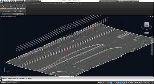
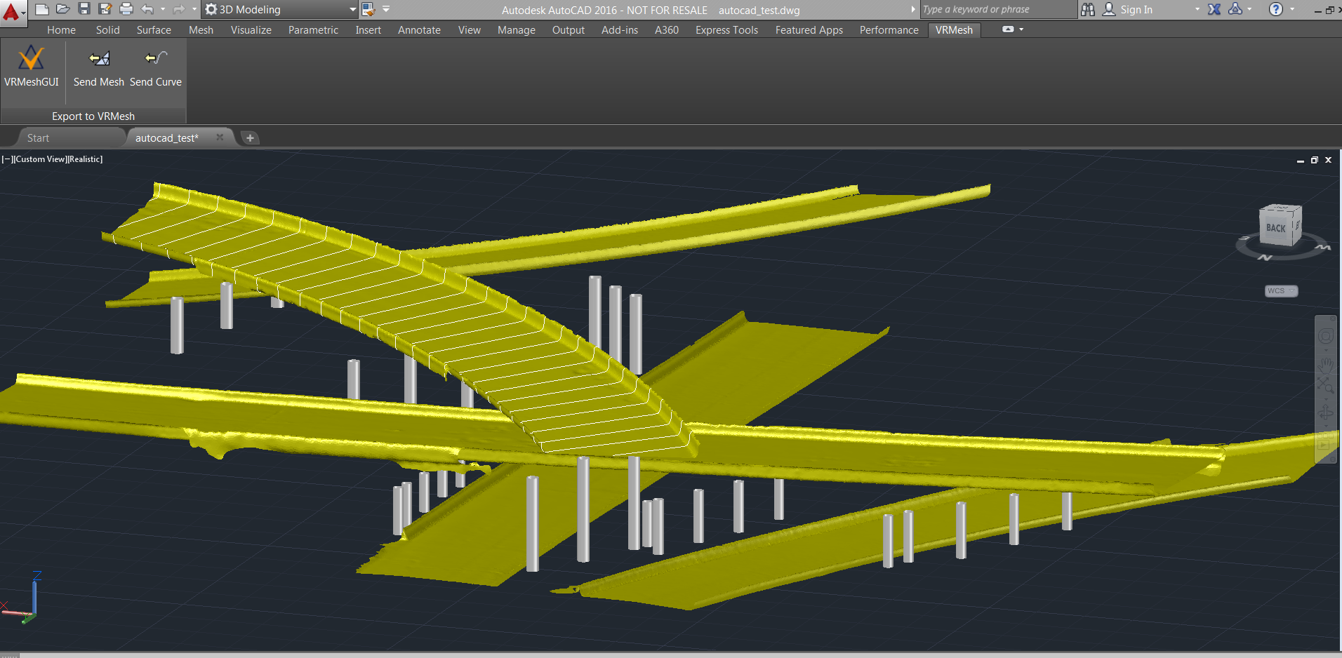
» 11/06/2018: VRMesh Plugin for AutoCAD/Civil 3D is available | ||||||||
Nov. 6th, 2018 - VirtualGrid is pleased to announce the availability of VRMesh plugin for AutoCAD/ Civil 3D 2019 and 2018, which allows Autodesk customers to send data between AutoCAD/Civil 3D and VRMesh. VRMesh is best known for its unique technologies in the fields of 3D point cloud and mesh processing, including automatic point cloud classification, feature extraction, high accurate triangle meshing, and advanced mesh editing. It works with all kinds of point cloud no matter from airborne, mobile, terrestrial LiDAR, or from photos, and provides flexible workflows to Civil 3D users for helping them make augmented reality modeling much easier.
A large set of tools in VRMesh enables users to quickly clean up and organize point clouds, effectively analyze and extract valuable features from massive data, and easily generate high-quality mesh surfaces for a broad array of Industries, such as road resurfacing, corridor redesign, tunnel construction, track gauge measurement, etc. VRMesh helps Civil 3D users maximize their productivity and make their civil construction work become easier. For a live demonstration, please stop by Booth A310 at Autodesk University 2018 in Las Vegas from Nov. 13 - 15, 2018. We are pleased to show you our innovative technologies. | ||||||||
» 11/01/2018: VRMesh V10.1 Improves Workflow on Point Cloud Cleanup and Road Resurfacing | ||||||||
Nov. 1st, 2018 - VirtualGrid is pleased to announce the availability of VRMesh v10.1, the latest version of its powerful 3D point cloud and mesh processing software. VRMesh is best known for its unique technologies including automatic point cloud classification, feature extraction, high accurate triangle meshing, and advanced mesh editing. This new release has added new features and streamlined work processes to focus on point cloud cleanup and road resurfacing. VRMesh v10.1 provides a simple and fast way for cleaning up and organizing point clouds. It adds a new feature for region reclassification, redesigns plane detection, and enhances the file split functions that allow you to classify BIM point clouds, separate points into different files, and export them directly into an Autodesk index file (*.rcp) for use in Autodesk software suites.
Meanwhile, a Terrain Resurfacing command is added with the aim of improving the workflow of road resurfacing. You can easily fit a spline surface on a terrain surface with the control of slope and elevation to generate a new surface. It can also be used to inspect surface roughness.
Additionally, the measurement features are improved with better labeling. The Measure Deviation command shows an accurate and easy-to-read cross section chart. The Inspection command adds value labels to an object in the main window and allows you to export a screenshot to a PDF report. With this new release, VRMesh provides more flexible workflows for processing all kinds of point clouds generated from airborne, mobile, terrestrial LiDAR, or from photos. You can quickly classify and clean up point clouds, extract different feature lines, generate high accurate surface meshes from point clouds, and make an inspection between surfaces or measure deviations in the cross-section viewport. In short, VRMesh is an industry-leading software product that maximizes your productivity and makes your job easier. For a live demonstration, please stop by Booth A310 at Autodesk University 2018 in Las Vegas from Nov. 13 - 15, 2018. We are pleased to show you our innovative technologies. | ||||||||
» 3/14/2018: VRMesh V10.0 Released with a New Construction Module | ||||||||
Mar. 14th, 2018 - VirtualGrid is pleased to announce the availability of VRMesh v10.0, the latest version of its powerful 3D point cloud and mesh processing software. VRMesh is best known for its unique point cloud classification method, extensive feature extraction functions, and accurate triangular meshing capabilities. This new release has added another exciting construction module that enables you to automatically fit polygonal surface to noisy point clouds for detecting road edges, curbs, traffic barriers, tunnels, etc. and also allows you to extract planar area from point clouds to create a low polygon building. The new construction module contains the following features:
With these cutting-edge technologies, VRMesh becomes the most comprehensive and powerful point cloud and mesh processing software in current market. Our customers come from a wide range of industries, including land surveying, construction, transportation, mining, architecture, manufacturing, gaming, medical and dental, etc. | ||||||||
» 10/12/2017: VRMesh V9.5 Available with New Advanced Features for LiDAR Strip Adjustment | ||||||||
Oct. 12th, 2017 - VirtualGrid is pleased to announce the availability of VRMesh v9.5, the latest version of its powerful 3D point cloud and mesh processing software. This new release provides a simple and fast way for LiDAR strip adjustment with high accuracy. It adds a new feature to separate overlapping LiDAR strips, redesigns and speeds up global registration over 10 times faster, and also allows you to generate a PDF report for viewing the quality of registration. The complete workflow of strip adjustment includes: Step 1: Separate overlapping LiDAR strips based on the selected trajectories Step 2: (Optional) Automatically classify vegetation in each strip to get a clean surface Step 3: Run global registration to fix the misalignment between the laser scanner and the inertial measurement unit (IMU)
The unique classification features in VRMesh can easily identify some noisy objects on the surface, e.g. vegetation, in each LiDAR strip to prevent these noises from disturbing strip adjustment. The global registration method works well for unstructured point clouds. With these cutting-edge technologies, VRMesh provides a flexible and accurate strip adjustment solution for both airborne and mobile LiDAR data. VRMesh is truly an industry-leading software product that maximizes productivity and reduces overhead costs. For a live demonstration, please stop by Booth 529 at Commercial UAV Expo 2017 in Las Vegas from Oct. 24 - 26, 2017. We are pleased to show you our innovative technologies. | ||||||||
» 4/20/2017: VRMesh V9.4 Adds More Feature Extraction Tools | ||||||||
April 20th, 2017 - VirtualGrid announces the availability of VRMesh v9.4, the latest version of its powerful 3D point cloud and mesh processing software. VRMesh v9.4 offers more feature extraction tools allowing you to quickly pick a line along a ridge, railway, powerline, etc. You can process any data not only acquired from airborne, terrestrial, or mobile laser scanners, but also generated from UAV images. Furthermore, in this version, more measurement tools are available.
The key improvements have been summarized as follows:
This new release improves the workflow efficiency of VRMesh in the field of land surveying, construction, transportation, mining, architecture, manufacturing, etc. For a live demonstration, please stop by Booth 1230 at AUVSI XPONENTIAL 2017 in Dallas from May 8 - 11, 2017. We are pleased to show you our innovative technologies. | ||||||||
» 10/28/2016: VRMesh V9.3 with Texture Add-on Launches at UAV Expo 2016 | ||||||||
Oct. 28th, 2016 - VirtualGrid is pleased to announce the availability of VRMesh v9.3, the latest version of its powerful 3D point cloud and mesh processing software. VRMesh is best known for its cutting-edge technologies including automatic point cloud classification, feature extraction, high accurate triangle meshing, and advanced mesh editing. This new release has added texture and several concept design tools, with the aim of improving the workflow efficiency of VRMesh in the field of land surveying, construction, transportation, architecture, manufacturing, entertainment, etc. The texture add-on is able to convert vertex colors to texture. Later, these 3D textured meshes can be decimated to an appropriate size for visualization and 3D printing. This new feature has expanded the capabilities of VRMesh to better serve our customers and satisfy their requirements when processing data from airborne, mobile, terrestrial LiDAR, and UAV images. VRMesh v9.3 has also added several mesh editing tools for mine modeling, such as Open Cut, Pavement Brush, Elevation Brush, Sculpt Contour, etc. These new tools let customers do interactive terrain design directly on 3D scan data. Meanwhile, classification and mesh processing functions have been speeded up significantly. For a live demonstration, please stop by Booth 610 at Commercial UAV Expo in Las Vegas from Oct. 31 - Nov 2, 2016. We are pleased to show you our innovative technologies. | ||||||||
» 7/8/2016: VRMesh V9.2 Release Added Curb Fitting for LiDAR Data and UAV Images | ||||||||
July 8th, 2016 - VirtualGrid announces the availability of VRMesh v9.2, the latest version of its powerful 3D point cloud and mesh processing software. VRMesh v9.2 adds a new function which automatically traces curb edges and fits curbs seamlessly on a surface mesh. Furthermore, in this version, point cloud classification is able to classify point clouds not only acquired from airborne, terrestrial, or mobile laser scanners, but also generated from UAV images.
This new release provides a complete workflow solution for transportation and urban design users, including automatic point cloud classification and feature extraction tools, accurate surface generation tools, and powerful curb fitting tools. It greatly shortens the time for road design and makes reality computing much easier. The key features added in version 9.2 include:
To celebrate the new release, VRMesh provides a limited-time offer - save 20% on all product options. Meanwhile, VRMesh has created a lite version of VRMesh Survey for users who need the classification functions only.
| ||||||||
» 2/18/2016: VRMesh Plugin for AutoCAD 2016 Is Released | ||||||||
Feb. 18th, 2016 - VirtualGrid is pleased to announce the availability of VRMesh for AutoCAD, a plugin application for AutoCAD 2016 and its family products (Architecture, Civil 3D, Map 3D...). This release includes two plugins, VRMesh Studio and VRMesh Reverse, which allow AutoCAD users to quickly and easily classify point clouds, extract features and create accurate triangle meshes. VRMesh Studio for AutoCAD includes all features in VRMesh covering from point cloud classification to triangle mesh generation. It uses a simple and straight-forward approach to help users generate a clean ground surface. It allows users to extract building footprints, poles, curbs, railways, power lines and tree crowns from point clouds. It also delivers best-in-class point cloud clean-up tools and mesh processing functionalities. VRMesh Reverse for AutoCAD enables users to handle large datasets of triangle meshes. Users can decimate and de-noise point clouds, convert point clouds to accurate meshes, reshape road curbs, extract pipes, compare cross-sections of a scanned object to its CAD model, etc.
VRMesh provides AutoCAD users a comprehensive set of point cloud and mesh processing tools which makes reality computing much easier. | ||||||||
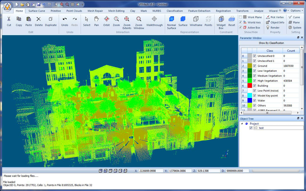
» 2/1/2016: VRMesh 9.0 Released with New Ribbon Interface and Significant Product Enhancements | ||||||||
Feb. 1st, 2016 - VirtualGrid is exited to announce the availability of VRMesh v9.0, the latest version of its powerful 3D point cloud and mesh processing software. VRMesh is best known for its unique point cloud classification workflow, extended feature extraction capabilities, and high accuracy of triangle meshing. This new release offers more control than ever over these cutting-edge technologies through a new intuitive user interface, new integrations, and enhanced work efficiency. The key improvements have been summarized as follows:
With the launch of version 9.0, VRMesh has reached a new level of maturity. Our customers come from a wide range of industries, including land surveying, civil engineering, mining, architecture, manufacturing, gaming, etc. | ||||||||
» 6/30/2014: VRMesh v8.5 Released for Classifying Powerlines, Poles, and Tree Crowns | ||||||||
Jun. 30th, 2014 - VirtualGrid is pleased to announce the availability of VRMesh v8.5, the latest version of its powerful 3D point cloud and mesh processing software. This new release has significantly extended and enhanced the usability of VRMesh Survey module for LiDAR point cloud processing. The key improvements in version 8.5 include:
With these new and enhanced capabilities, VRMesh has significantly improved the workflow efficiencies of VRMesh Survey. It becomes the most complete solutions for automatic point cloud classification,feature extraction, and triangulation in the field of airborne and mobile LiDAR processing. | ||||||||
» 2/11/2014: VRMesh Triangulation for AutoCAD Is Released | ||||||||
Feb. 11st, 2014 - VirtualGrid is pleased to announce the formal release of VRMesh Triangulation for AutoCAD, a plugin application for AutoCAD 2014 and its family products (Architecture, Civil 3D, Map 3D...). It allows users to quickly and easily wrap point cloud data into accurate triangle meshes as well as create cross-section curves within the AutoCAD environment. Key features include:
With VRMesh's cutting-edge technologies, the plugin provides AutoCAD users with a powerful tool for point cloud and mesh processing that can be used in the field of urban planning, architecture, civil engineering construction, transportation, gaming, etc. | ||||||||
» 1/30/2014: VRMesh v8.0 Released for Point Cloud and Mesh Processing | ||||||||
Jan. 30th, 2014 - VirtualGrid is pleased to announce the availability of VRMesh v8.0, the latest version of its powerful 3D point cloud and mesh processing software. VRMesh provides cutting-edge solutions for automatic point cloud classification, feature extraction, and accurate triangle mesh generation. This new release has mainly focused on improving workflow efficiencies of VRMesh Survey and VRMesh Reverse, with the aim of enhancing the usability of VRMesh in urban planning and civil engineering construction. In VRMesh Survey module, new features are added to automatically detect railways and curbs in LiDAR point clouds. Grid surface can be exported as Esri ASCII Grid format for use in downstream Industries. Meanwhile, building roof identification has been enhanced. Building footprint extraction becomes more accurate. In VRMesh Reverse module, point cloud decimation has been speed up and also reorganized to make more uniform distribution of points on flat regions. The process of point cloud triangulation has been significantly improved.
With these new and enhanced capabilities, VRMesh becomes the most powerful point cloud and mesh processing software in current market. Our customers come from many fields such as defense, transportation, urban planning, architecture, mining, manufacturing, gaming, etc. | ||||||||
» 3/18/2013: VRMesh v7.6 Released with Enhanced Performance | ||||||||
Mar. 18th, 2013 - VirtualGrid announces the availability of VRMesh v7.6, the latest version of its powerful 3D point cloud and mesh processing software. This new release mainly focuses on performance improvement in all functional areas. The key improvements in version 7.6 include:
With the launch of version 7.6, VRMesh has reached a new level of maturity. It delivers best-in-class solutions for point cloud classification, triangle meshing, and STL editing. Our customers come from a wide range of industries, including land surveying, mining, manufacturing, architecture, dental implant, gaming, etc. | ||||||||
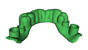
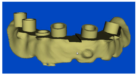
» 3/18/2013: Dental Drill Guide Design in VRMesh v7.6 | ||||||||
Mar. 18th, 2013 - VirtualGrid announces the availability of VRMesh v7.6. This release adds several new capabilities to streamline the process of creating a drill guide for dental implant surgery. The entire workflow for dental drill guide design includes:
The new version combines all these steps into a batch process module to provide users a simple way for creating a drill guide, which significantly reduced the number of clicks that users need to take. Users just need to define a region of interest, and the program will automatically generate a water-tight drill guide for 3d printing.
For detailed information, please refer to the following materials: Drill guide design - PDF tutorial: Drill guide design - YouTube video: http://youtu.be/91rRfCKL0To | ||||||||
» 1/14/2013: VRMesh Plugin for ArcGIS Released for Point Cloud Classification and Triangle Meshing | ||||||||
Jan. 14th, 2013 - VirtualGrid is pleased to announce the release of VRMesh plugin for ArcGIS Desktop 10.1. This release includes two plugins, VRMesh Classification and VRMesh Triangulation, which enable users to automatically classify point clouds and generate accurate triangle meshes within the Esri ArcGIS environment. VRMesh Classification for ArcGIS provides best-in-class point cloud classification and feature extraction technologies for LiDAR data processing. It uses a simple and straightforward approach to extracting vegetation, building roofs, and ground points from airborne and mobile LiDAR data. 99% classification jobs can be done automatically and accurately. It also allows you to extract building footprints and create 3D buildings in one click. VRMesh Triangulation for ArcGIS allows you to wrap point cloud data into accurate triangle meshes. It delivers the most advanced point cloud clean-up and triangulation functionalities for generating an accurate TIN surface from LiDAR data no matter how complex the terrain topography is. Product Brochure PDF: VRMesh Classification YouTube Video: http://youtu.be/ZfjV6yxwK1M VRMesh Triangulation YouTube Video: http://youtu.be/uFkurJm2O_k | ||||||||
» 10/9/2012: VRMesh Library available for Point Cloud Classification and Triangle Meshing | ||||||||
Oct. 9th, 2012 - VirtualGrid announces the release of VRMesh library, providing advanced technologies for point cloud classification, triangle meshing, and mesh editing. These technologies can be used in a wide range of industries such as land surveying, manufacturing, medical and dental, etc. Our goal is to give you advanced technologies at an affordable price to build better quality Industries in less time, help you succeed, and win in your market. VRMesh library consists of three parts:
VRMesh library is written in C++, compiled as DLL files, and compatible with Microsoft Windows. The input and output (I/O) methods are left open to your application. We welcome enquiries from companies interested in adding or integrating our technologies with their products and solutions. Please contact us for complete details and scheduling. | ||||||||
» 9/19/2012: VRMesh v7.5 Released for Triangulation of Large Point Clouds | ||||||||
Sep. 19th, 2012 - VirtualGrid announces the availability of VRMesh v7.5, the latest version of its powerful 3D point cloud and mesh processing software. VRMesh provides an advanced solution covering the complete workflow from automatic point cloud classification to accurate surface mesh generation. This new release has specially focused on the high accuracy and efficiency in triangulation of large point clouds.
The key improvements in version 7.5 include:
With these new and enhanced capabilities, VRMesh becomes the most powerful point cloud and mesh processing software in current 3D scanning market. Our customers come from many fields such as defense, mining, urban design, transportation, manufacturing, medical and dental, gaming, etc. | ||||||||
» 4/2/2012: VRMesh v7.1 Available with Enhanced Features | ||||||||
April 2nd, 2012 - VirtualGrid announces the availability of VRMesh v7.1, the latest version of its powerful 3D point cloud and mesh processing software. This new version delivers extended capabilities for LiDAR data processing. New and Enhanced Features include:
| ||||||||
» 2/27/2012: VRMesh v7.0.2 Released with Enhanced Point Cloud Classification Capabilities | ||||||||
Feb. 27th, 2012 - VirtualGrid releases VRMesh version 7.0.2 with enhanced capabilities for automatic point cloud classification. The improvements in this release include:
VRMesh provides a next-generation solution for automatic point cloud classification and feature extraction. Please feel free to try a demo version of VRMesh v7.0.2. | ||||||||
» 1/23/2012: VRMesh v7.0 Announced for LiDAR Point Cloud Classification at ILMF 2012 | ||||||||
January 23rd, 2012 - VirtualGrid announces the availability of VRMesh version 7.0 at the International LiDAR Mapping Forum (ILMF) in Denver. Please visit Booth 95 to learn about our cutting-edge point cloud classification and feature extraction technologies. This new release has significantly extended and enhanced the usability of VRMesh Survey module in the field of LiDAR data processing. The key contributions of VRMesh Survey are its unique capability to automatically classify point clouds under extreme variations in terrain and its excellent functionalities that allow you to extract building footprints and create 3D buildings in one click. Unlike traditional LiDAR data processing workflows that have to extract ground points first before classifying vegetation and buildings, the first fundamental step in VRMesh Survey is to detect vegetation. It provides a next-generation solution to automatically extract vegetation, buildings, and ground points from LiDAR data, no matter the data is gathered from steep slopes covered with dense vegetation or areas where there is very few ground points available. Key features of VRMesh Survey empower users to:
Please stop by Booth 95 at ILMF 2012 for a live demonstration. We are pleased to show you our innovative technologies. We provide stand-alone Industries, and also provide customized versions upon customers' specifications. | ||||||||
» 11/17/2011: VirtualGrid to Introduce Point Cloud Classification at AU 2011 | ||||||||
|
Nov. 17th, 2011 - This year at Autodesk University, VirtualGrid will introduce VRMesh Survey, their latest software product for automatic and accurate point cloud classification. Please visit Booth 6A (Nov. 29th - Dec. 1st, 2011, Las Vegas) to learn about the powerful point cloud capabilities in VRMesh Survey. VRMesh has become known for its cutting-edge point cloud and mesh processing functionalities. The latest product VRMesh Survey, an automatic point cloud classification solution, has been used worldwide by surveying, mining, civil engineering, and urban design companies, as well as governmental and university organizations. Key features of VRMesh Survey empower users to:
The new and enhanced features in VRMesh v7.0 Survey will give users the ability to detect ground points in steep terrain and the ability to create 3D buildings based on extracted footprints.
Please stop by Booth 6A at AU 2011 for full demonstrations. Or watch an introductory video from here. | ||||||||
» 2/18/2011: Automatic Point Cloud Classification Available in VRMesh v6.0 | ||||||||
|
February 18th, 2011 - VirtualGrid announces the availability of VRMesh v6.0, the latest version of its powerful 3D point cloud and mesh processing software. This release has significantly extended and enhanced its point cloud processing capabilities. The biggest breakthrough in this release is the new VRMesh Survey module introduced for automatic LIDAR point cloud classification and bare-earth extraction. These innovative technologies provide users a simple workflow to automatically and accurately classify LIDAR point clouds into ground, vegetation, building, and others. More than 90% identification jobs will be done in a one-click process. And also, manual adjustments can be easily performed in a cross section view. Compared to others on the market, the major advantages of VRMesh Survey module are as follows:
| ||||||||
» 2/18/2011: STL Editing Significantly Improved in VRMesh v6.0 | ||||||||
|
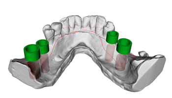
February 18th, 2011 - VirtualGrid announces the availability of VRMesh v6.0. Besides the introduced VRMesh Survey module, another significant update in this release is the enhancement of its STL repair and editing capabilities. The new version includes numerous improvements, such as Boolean, offsetting, hole-filling, triangle error fixing, etc., which have greatly improved VRMesh usability and performance in 3D printing industry. The VRMesh Design module, delivering advanced STL file repairing and editing capabilities, is especially suitable for dental implant treatment planning, orthographic surgery planning, customized shoe insole design, etc. It allows practitioners to easily prepare STL files for template fabrication. The following image illustrates the effective use of VRMesh Design in surgical template preparation for dental implants. View Case Study »
"It is a pleasure working with VRMesh team. They were attentive to our needs, understood what we were trying to accomplish and went above and beyond to provide support and answer questions. They even modified the software to create a module that makes the software easier for us and our partners to use." said Michael Saltzman, Director of Blue Sky Plan, "I highly recommend the VRMesh software to anyone looking for a valuable STL editing tool." In addition, several new STL editing features have been included in this release, e.g. triangle refinement, edge connection optimizing, labeling, etc.
Please feel free to try the demo version and compare the results with your favorite STL editing suite. | ||||||||